
About the topic
Bio
Get the Flyer (PDF)
About the topic
From a UC Boulder press release:
Faculty and students from the University of Colorado at Boulder's Research and Engineering Center for Unmanned Vehicles teamed with researchers from the University of Nebraska-Lincoln for the first interception of a "supercell" thunderstorm by an unmanned aircraft system on May 6. The Tempest unmanned aircraft developed at CU-Boulder flew for 44 minutes, covering roughly eight miles along a gust front south of the thunderstorm in northwestern Kansas.
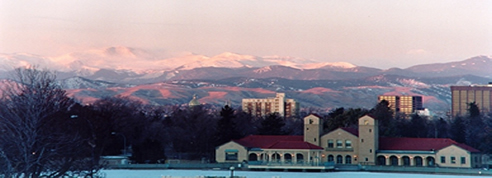
The supercell intercept was part of the second Verification of the Origins of Rotation in Tornadoes Experiment, or VORTEX2, field campaign. VORTEX2 is the largest tornado field project in history, taking place May 1 through June 15, and involving more than 100 scientists and 40 support vehicles. The researchers are literally surrounding severe storms ? known as supercells ? with the latest technology to learn more about their birth, duration and wind speeds and to assess death, injury and damage potential. In addition to heavy rain and damaging hail and winds, supercell storms produce the largest and most violent tornadoes.
The target of the unmanned vehicle team's first supercell intercept was the gust front that typically rolls out to the south and east of a supercell storm as it moves to the east-northeast, said Tempest team leader and aerospace engineering sciences Professor Brian Argrow. The interception combined technical, operational and regulatory operations barriers to field the Tempest UAS, or unmanned aircraft system. Lack of atmospheric data in and around supercell thunderstorms required the design of an aircraft that is robust over a range of flight conditions. Networked communication, command and control were developed and demonstrated in order to allow multiple operators and scientists to monitor the aircraft and its measurements of the environment in real time, Argrow said.
Uncertainty in storm formation and the quick evolution of the severe conditions that were the target of the mission also required a fast operational pace in which the CU-Boulder team had to locate an area for launch and deploy the aircraft in a matter of minutes. While flight in the U.S. National Airspace System required compliance with Federal Aviation Administration guidelines, the team has worked with the FAA over the past several years to refine the aircraft system and operational procedures in order to satisfy the FAA regulations. "This was an exciting demonstration of the technologies and deployment capabilities that our UAS team has developed over several years. It is a great example of how engineers -- faculty, students and researchers -- can be given scientific mission requirements and then design, build, test and operate sophisticated systems that meet those requirements," said CU-Boulder Assistant Professor Eric Frew, a Tempest team member.
After spending most of May 6 positioning for storms that were forecast to develop in northwestern Kansas, the UAS team set up in Hill City, where it was joined later by the rest of the VORTEX2 armada of Doppler radar trucks, a network of automated, mobile weather stations and other instruments. Argrow served as mission commander and drove the UAS mobile ground control station to the deployment site about 20 miles northwest of Hill City. The mobile ground control station is the communications nexus for the UAS team where weather radar data is overlaid onto road maps, and the software for situational awareness displays the locations and movements of all vehicles in the VORTEX2 armada connected through the Internet. Assistant Professor Adam Houston of NU-Lincoln was the team's lead meteorologist, providing directions to the various vehicles making up the team. The vehicles included a "tracker" to which the unmanned aircraft is electronically leashed and a "scout" vehicle that drove ahead of the tracker to be certain the roads were passable and prevent the tracker from taking the unmanned aircraft into regions with large hail or heavy precipitation. Frew drove the scout vehicle, and doctoral students Maciej Stachura and Jason Durrie directed the Tempest from the tracker.
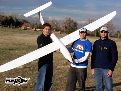 At the launch site, CU-Boulder research assistant Tom Aune and doctoral students Jason Roadman and Tony Carfang prepared and launched the Tempest unmanned aircraft. CU-Boulder doctoral student Jack Elston, the pilot-at-controls, then commanded the Tempest into autonomous mode and set it to circle the tracker vehicle.
Computers in the ground control station and in the tracker are connected to a computer in the unmanned aircraft through a 2.4-GHz (WiFi) wireless network, and a second radio link that has a greater range. The systems allow communications messages and commands to be sent from both the ground control station and the tracker vehicle to the unmanned aircraft, while the Tempest flight computer reports its GPS position, health and status, and real-time meteorological data.
"Team members Cory Dixon, Maciej Stachura and I have put in many hours to develop the communications and controls systems that are now the RECUV mobile ground station and Tempest UAS," said Elston. "Our advisers have allowed us to work in a research environment with the freedom to collaborate and develop our best ideas into the systems we operate today."
At the launch site, CU-Boulder research assistant Tom Aune and doctoral students Jason Roadman and Tony Carfang prepared and launched the Tempest unmanned aircraft. CU-Boulder doctoral student Jack Elston, the pilot-at-controls, then commanded the Tempest into autonomous mode and set it to circle the tracker vehicle.
Computers in the ground control station and in the tracker are connected to a computer in the unmanned aircraft through a 2.4-GHz (WiFi) wireless network, and a second radio link that has a greater range. The systems allow communications messages and commands to be sent from both the ground control station and the tracker vehicle to the unmanned aircraft, while the Tempest flight computer reports its GPS position, health and status, and real-time meteorological data.
"Team members Cory Dixon, Maciej Stachura and I have put in many hours to develop the communications and controls systems that are now the RECUV mobile ground station and Tempest UAS," said Elston. "Our advisers have allowed us to work in a research environment with the freedom to collaborate and develop our best ideas into the systems we operate today."
The UAS team is currently waiting for its next chance to deploy with the VORTEX2 armada to intercept another supercell storm in the zone where it has received FAA permission to fly. The boundary of the UAS operations zone runs east along the north side of I-70 from around Byers, Colo., to WaKeeney, Kan., turns north to I-80 near Lexington, Neb., then northwest to the Wyoming border near Scottsbluff, Neb. From there it turns south through the Pawnee National Grassland east of Fort Collins and back to Byers. "With all our technical achievements on display during this deployment, the regulations and policies of the FAA remain the biggest challenge to our operations," said Argrow. "However, we have worked closely with the FAA for the past three years and we applaud the FAA staff for approving the certificates that allow us to operate."
A second CU-Boulder team led by Assistant Professor Katja Friedrich of the atmospheric and oceanic sciences department is deploying a set of disdrometers as part of VORTEX2 to measure the size and velocity of precipitation droplets. Learn more about the VORTEX2 UAS team
Bio
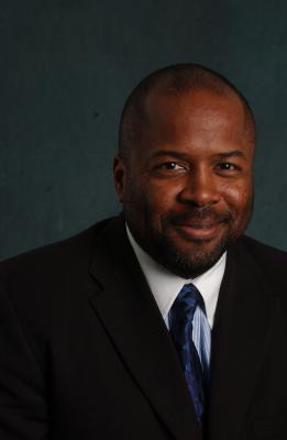 BRIAN ARGROW is Professor of Aerospace Engineering Sciences, and cofounder and director emeritus of the Research and Engineering Center for Unmanned Vehicles at the University of Colorado Boulder. His research ranges from small unmanned aircraft systems design, and their integration into the airspace, to satellite aerodynamics, sonic boom, and engineering education. He has received several teaching and education awards including the W.M. Keck Foundation Award for Excellence in Engineering Education, and is a University of Colorado Presidents Teaching Scholar. He served as associate dean for education 2007-2012. In 2007 he was co-chair of the first Symposium for Civilian Applications of Unmanned Aircraft Systems (CAUAS), and since 2008 he has chaired workshops and moderated several national panels on research directions for the integration of UAS into the National Airspace System. He is an associate fellow of the American Institute of Aeronautics and Astronautics (AIAA) and is chair-emeritus of the AIAA Unmanned Systems Program Committee. In 2009, he received the Air Force Exemplary Civilian Service Award for service on the Air Force Scientific Advisory Board and is currently a member of the NASA Advisory Councils UAS Subcommittee. In 2010 he led the first UAS team to intercept supercell thunderstorms as part of the VORTEX2 field campaign.